 |
|
|
| |
| Environment/objects of interest |
- Nahe Valley
- Soonwald
- Idarwald
- Hochwald
- Mosel Valley
- Rhein Valley
- Districts
The romantic Nahe valley
 The headwaters of the Nahe river lie in a forest valley, 460 m above sea level, above the village of Selbach in the Saarland district of St. Wendel. The constantly changing landscape with its extensive forests, narrow ravines, and wide floodplains that abruptly open up, follow the river on its 112 km route to the Rhine. On the upper Nahe, in the Idar-Oberstein area, one finds semi-precious stones such as agates, amethysts, mountain crystals and chalcedony, which were commercially mined until the end of the 19th Century. In Kirn, the next largest small town, there is a splendid view from the ruins of Kyrburg. A little downstream from Bad Sobernheim , at the foot of Disibodenberg ,
the largest tributary, the water-rich Glan, flows into the Nahe. In the Glan valley lies Meisenheim , with an old town from the Middle Ages which is worth seeing. From Disibodenberg, the Nahe flows onwards to Bad Münster am Stein and Bad Kreuznach, where saltwater springs are the basis for the health and spa industry. In the past, these saltwater springs also served as sources for salt (salt works and graduation houses). A few kilometers northwest of Bad Kreuznach, in the Ellerbach valley, lies Sponheim with the former monastery church of St. Martin, the most significant romanesque building in the Nahe-Hunsrück region. Near Bingen the Nahe finally reaches the Rhine.
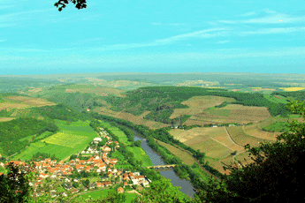
Above is a picture from Lemberg, which is near Bad Münster am Stein in the middle of a 100,000 hectare nature preserve with steep mountain slopes covered by enormous amounts of scree and many rare plants. From the peak of Lemberg one has an unparalleled view of the Nahe Valley below as well as over a wide part of Hunsrück. A picture book worth seeing: Naheland Impressionen; Kreisverwaltung Bad Kreuznach, 1994 The headwaters of the Nahe river lie in a forest valley, 460 m above sea level, above the village of Selbach in the Saarland district of St. Wendel. The constantly changing landscape with its extensive forests, narrow ravines, and wide floodplains that abruptly open up, follow the river on its 112 km route to the Rhine. On the upper Nahe, in the Idar-Oberstein area, one finds semi-precious stones such as agates, amethysts, mountain crystals and chalcedony, which were commercially mined until the end of the 19th Century. In Kirn, the next largest small town, there is a splendid view from the ruins of Kyrburg. A little downstream from Bad Sobernheim , at the foot of Disibodenberg ,
the largest tributary, the water-rich Glan, flows into the Nahe. In the Glan valley lies Meisenheim , with an old town from the Middle Ages which is worth seeing. From Disibodenberg, the Nahe flows onwards to Bad Münster am Stein and Bad Kreuznach, where saltwater springs are the basis for the health and spa industry. In the past, these saltwater springs also served as sources for salt (salt works and graduation houses). A few kilometers northwest of Bad Kreuznach, in the Ellerbach valley, lies Sponheim with the former monastery church of St. Martin, the most significant romanesque building in the Nahe-Hunsrück region. Near Bingen the Nahe finally reaches the Rhine.
Above is a picture from Lemberg, which is near Bad Münster am Stein in the middle of a 100,000 hectare nature preserve with steep mountain slopes covered by enormous amounts of scree and many rare plants. From the peak of Lemberg one has an unparalleled view of the Nahe Valley below as well as over a wide part of Hunsrück. A picture book worth seeing: Naheland Impressionen; Kreisverwaltung Bad Kreuznach, 1994 |
Soonwald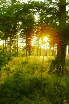
The Soonwald is one of the largest contiguous areas of forest in Germany. Its altitude (400-600 m; the highest peak is Ellerspring at 657 m), its low population density, and its distance from the large transportation routes of our time make it an ideal recreation area for people seeking peace and quiet. This wooded area is well developed. It has over 800 km of circular hiking paths with observation towers at the most beautiful spots, which afford spectacular panoramas. You can hike here for hours without ever meeting another human being, although traces of more than two thousand years of human history can be found everywhere. There are, on the heights of mountain ridges, ancient Celtic hilltop forts, surrounded by gigantic stone walls which easily exceed several hundred meters in length; there are ancient Roman long-distance roads, constructed some 2,000 years ago at a standardized width of 5 to 6 meters and protected by watchtowers at regular
intervals; and there are the remains of luxurious Roman villas. In addition, we find medieval fortresses and castles from the glory days of the political might of Sponheim and Kurtrier. And, there are churches and monasteries in the architectural style typical of Hunsrück with ingeniously painted surfaces and galleries; evidence of a very special race of people, who despite difficult living conditions and scant resources created their own works of art over hundreds of years. A race of people who, incidentally, you still encounter today on the farms of the elevated plains or in the village guest houses.
A picture book worth looking at: Uwe Anhäuser, Kultur-Erlebnis Hunsrück; Idar-Oberstein: Dr. Gebhardt & Hilden, 2000
Wanderführer: Wolfgang Bartels, Hunsrück; DuMont Buchverlag, 1996 und Norbert Forsch, Hunsrück; Deutscher Wanderverlag, 2000
Ergänzende Literatur: Landesgeschichtlicher Exkursionsführer Hunsrück; mit Beiträgen von A. Bauer, B. Lipps, W.H. München, E. Schaaf und K.H. Weichert, Herausgeber: Hunsrückverein e.V., Arbogast Verlag Otterbach, 1993 |
Idar-Oberstein, the German gem center 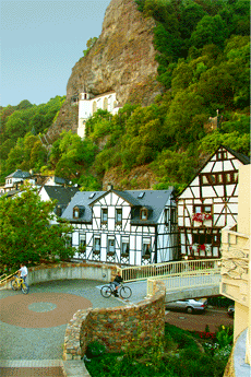
In the narrows between steep, rocky cliffs and the banks of the Nahe River lies Idar-Oberstein. Since every square meter of land is at a premium here, the river has been covered over by the town. This means that since 1986 the Nahe has flowed underneath the town for several kilometers. The world famous Felsenkirche (a church from 1482-1484), the construction of which is traced to a story of fratricide, is built high above the old town into a vertical rock wall and gives Idar-Oberstein quite a unique character. The steep steps leading up to Felsenkirche are climbed every year by countless visitors from all over the world, whose efforts however are more than rewarded by impressive works of art there. Examples are a Gothic winged altar from 1410 and a beautiful Stumm organ from the year 1756. The setting of both the old and the new castles high above Felsenkirche gives the visitor a feel for how proudly enthroned above the town and valley the
lords of Dhaun and Oberstein castles were in the Middle Ages. In addition to Felsenkirche, the town is well known for its agate cutting. There is actually no other excavation site in Europe as famous as the Idar-Oberstein region for its enormous variety of agates in the most varied forms and colors. The "birth" of agates lies in the Permian period 285 million years ago and is attributed to the pronounced volcanism in the Nahe Valley. Agates fill hollow cavities in volcanic rock, however it is not exactly clear how the quartz accumulates in the cavities and is transformed to agates. Smoky quartz, amethysts, jasper and calcite have also formed in this time. Originally, agate cutters worked on the semi-precious stones from the region (commercial mining from 1375-1875) in their small cutting shops along the water-rich streams, which flow from the Idarwald and Hochwald heights to the Nahe River. Today the raw stones are imported from all
over the world. In addition to the agate cutting, a highly developed jewelry industry evolved, which also encompasses the trade of precious stones and pearls. No wonder that Idar-Oberstein became one of the leading international centers for the jewelry industry, where dreams of agates, and also other precious stones entice many.
A few kilometers upstream from Idar-Oberstein the Siesbach, coming from the Hochwald heights, flows into the Nahe river. In former times this quite insignificant stream formed the border between the Roman provinces Gallia Belgica and Germania Superior, and later between the jurisdictions of the archbishoprics of Trier and Mainz. During the years 1976/1977 a large Gallic-Roman burial mound was completely excavated at the headwaters of Siesbach in the forest-region "Kipp" at the foot of Hochwald. From its grave decorations and inventory from the graves the influence of the Roman culture on the native people of the Celtic Treverians can be impressively documented. This archaeological memorial, which possseses more than just local significance, was used as family burial ground between 167 and 174 AD by a distinguished and
evidently wealthy Treverian family for three interment ceremonies and was completed around the year 175 AD. For an overview of the Celtic and Roman history an excursion to the museum in nearby Birkenfeld. is certainly worthwhile. A visit to the Gallic-Roman burial mounds near the town of Siesbach can be easily combined with a hike around the Idar-Oberstein region: follow Idarbach creek past the water mill 'Weiherschleife' (with its water-driven tools for grinding and polishing agates), to the "peace oak", from there walk to Hettenrodt and then past Siesbach to the small forest road "Strudtchaussee" at the foot of Ringskopf mountain. For those who prefer to travel in comfort, you can tour this area by car on a small road that begins in the town of Kirschweiler and passes the golf course below
Kirschweiler Fortress.
For further information: Brandt H.P., Zur Geschichte des Achatbergbaus im Nahegebiet. In: H.P. Brandt (Hrsg.) Geschichte des Bergbaus an der oberen Nahe, Charivari Idar-Oberstein, 1978 und Gilles K.J., Die Römer im Birkenfelder Land —römischer Grabhügel "Kipp" bei Siesbach. Mitteilungen des Vereins für Heimatkunde, Sonderheft 47, Birkenfeld 1985: 81-100
Johann Michael Stumm (1683-1747), was an organ builder of Hunsrück who was well known far beyond his own region of Sulzbach in the Idarwald region. He founded an organ building dynasty that produced more than 200 beautifully hand made instruments of excellent sound quality. |
Hochwald with the Erbeskopf (818 m) 
The Hochwald with its dense forests surrounding the 818 meter high Erbeskopf (the highest mountain west of the Rhine in Germany) is a fertile source of sagas and heroic tales. Many researchers of local history suspect that here in this pristine area of the Hunsrück plays one of the central scenes of the medieval Nibelungenlied.
In this place, according to the saga, Hagen von Tronje slew the noble hero Siegfried at the behest of Brunhilde. In fact, Drohnecken castle at the foot of Erbeskopf mountain is thought to be a possible family seat of Hagen von Tronje. Hagen's friend Hunold is thought to come from the nearby Hunolstein castle. Moreover, the towns of Worms and Alzey —the most important locations in the Nibelungenlied— are little more than a day ride on horseback from the Hunsrück mountain range.
A picture book worth looking at: Uwe Anhäuser, Heimat am Idarwald; VG Rhaunen, 2001
Hiking Guides: Wolfgang Bartels, Hunsrück; DuMont Buchverlag, 1996 und Norbert Forsch, Hunsrück; Deutscher Wanderverlag, 2000 |
The Mosel valley from Trier to Koblenz 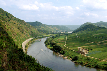
The Mosel river with its length of 545km, isn't even half as long as the Rhine. It has its source in the southern Vosges, from where it winds through the area of Trier in order to reach a branch of the Hunsrück.
From there, until it meets the Rhine at Koblenz, it flows through the deeply cut, winding valleys of the Rhenish slate mountains, creating a natural boundary at the north of the Hunsrück. The Mosel valley is an important wine growing area with famous names such as Bernkastel, Traben-Trarbach, Zell and Cochem.
Guide book: Reinhold Schommers, Mosel; DuMont Buchverlag, 2001 |
The Rhine valley from Bingen to Koblenz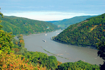
The Rhine has covered two thirds of its 1320 km long trip from the Swiss Alps (canton Graubünden) to the North Sea by the time it meets a branch of the Hunsrück near Bingen. Starting here, it flows through the slate mountains of the middle Rhine region. The traveler passes through a very narrow 300m deep ravine where the Hunsrück is a natural boundary. Then he traverses the fascinating landscape of Hunsrück on his way downstream.
Along this way he sees world famous places such as Bacharach, Kaub, or St. Goar with the overwhelming rock of Loreley. He sees Boppard with its impressive Rhine loop and picturesque Rhens. At Koblenz, at the mouth of the Mosel in the Rhine, he has reached the most northerly point of the branch of the Hunsrück. It isn't far from here and the Rhine widens, with all the narrows left behind. The low plains now determine the flow of the Rhine to the North Sea.
Hiking guide: Wolfgang Bartels, Hunsrück; DuMont Buchverlag, 1996 und Norbert Forsch, Hunsrück; Deutscher Wanderverlag, 2000 |
Three districts, one region: Nahetal-Hunsrück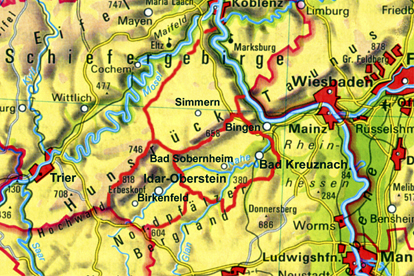
The region of the Nahe Valley-Hunsrück, the historic Nahegau, is divided into three administrative districts: to the east lies the district of Bad Kreuznach with its administrative seat in the city of Bad Kreuznach, to the north is the district of Rhein-Hunsrück with its administrative seat in Simmern, and to the west is the district of Birkenfeld with its administrative seat in the city of Birkenfeld. To the north there are also the districts of Cochem-Zell and Bernkastel-Wittlich bordering the Mosel river. Although the form these districts have today only dates from the administrative reform of the Rhineland-Pfalz region in 1969/1970, their origins can be found 200 years earlier. First under the French ruler Napoleon and then, after the reconstruction of Europe by the Viennese congress, under the Kingdom of Prussia. In fact, in the year 1798, under French
rule (1798-1814), the feudal system with its class privilege, serfdom and drudgery was eliminated, and, to ensure the division of authority, administrative and judicial powers were separated. All religious faiths received equal rights, and in 1804 these rights were implemented by a unified code of law, the Napoleonic civil code (Code civile Napoléon). As a result of an act of the Viennese Congress, the final act of 9 June 1815, the Prussians were awarded the area north of the Nahe. On 14 May 1816, the "royal government" in Koblenz officially announced the newly formed "districts" as administrative units, so this date is considered the official "birthday" of these districts.
It should be mentioned that the historical "Nahegau" only encompassed the eastern part of the District of Birkenfeld. The border ran along the Heimbach, a few kilometers west of Baumholder, along the Nahe up to Siesbach, just before Idar-Oberstein, along the Siesbach almost to the Erbeskopf, and from there over the ridge of the Idar forest to the Idarkopf. A look at the map here also shows that the mouth of the Nahe near Bingen (belonging to the district of Mainz-Bingen) and the northwestern part of Hunsrück (belonging to the districts of Cochem-Zell and Bernkastel-Wittlich) complete the region.
Along with the federal and state duties dictated, the district administration is also responsible for schools, social welfare, youth welfare offices, building development, land utilization, and fire protection. In addition, it deals with waste management as well as the maintenance of local streets. Above and beyond these central administrative tasks, the district also provides for the economic development of the community and region. In this respect, the expression "sustainability", as well as sustainable development, plays a central role, since its professed goal is to ensure the "continuance of a balance in the relationship between nature and its ability to regenerate, on the one hand, with its claims by humans, on the other". Alongside its obligatory duties, the district also takes on so-called "voluntary" duties, depending upon the tax income. Among these are the maintenance of adult evening classes, music
schools, museums, theaters, sports fields, and swimming pools.
|
|
|
 |
|
|
|
|
|
|
|
Hotel Maasberg Therme • 55566 Bad Sobernheim • Tel: + 49 (0 67 51) 87 60 • Fax: + 49 (0 67 51) 87 62 01 • E-mail: info@maasberg-therme.de |


