 |
|
|
| |
| Environment/objects of interest |
- Nahe Valley
- Soonwald
- Idarwald
- Hochwald
- Mosel Valley
- Rhein Valley
- Districts
The Romans in the Nahe Valley and the Hunsrück
The Historical and Cultural Legacy
 After Caesar's conquest of Gaul between 58 and 51 BC, which was a devastating defeat for the Celts, wide reaches of Europe were united
for almost 500 years. This was the Roman empire under "Pax Romana" (Roman peace) with its own monetary and administrative system. Rome's historical and cultural influence with its progressive technology, high standard of organization and
well developed writing system had a fundamental and enduring effect upon the western world. How quickly the Romanizing process progressed after Caesar's conquest can be seen in the artifacts found in the graves of the Celtic Treverians of the Hunsrück. The newly founded Roman towns and villages did their best even when the heavy tax load they carried resulted in many uprisings.
Settling of Roman veterans was undertaken systematically for the purpose of ensuring continued provision for the military personnel and civil population. The most commmon type of settlement was the individual farmstead (latin: villa rustica). These varied greatly in size and were usually surrounded by a wall. A farmstead of this type was normally composed of a main residential building and a bath house as well as numerous other buildings having to do with the business of farming. In addition to agricultural activities and keeping of cattle, crafts were practiced such as metal and woodworking. As the economy grew more prosperous, pottery and ceramic workshops sprang up all over the country at places on roads with good clay deposits nearby ("Terra- Sigillata-Manufactories"), for example, south of the Nahe valley near Germersheim in the Pfalz. The center of a town was the Forum where the business people had their shops (latin: tabernae).
Education and Schools
Although the Celts of the Latène age knew the Greek alphabet, it was the Romans who put writing to real use (latin alphabet) making it a part of everyday life. As a result, it was not only the upper class that could read and write, but a majority of business people, craftsmen, soldiers, land owners and even slaves. This was the only way that the daily business with local and state institutions could be managed efficiently.
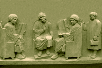
Regular school attendance was part of daily life for children although private schooling was a priviledge only for the upper classes. Citizens of any wealth at all would probably have had a small private library of the "classics" of that time. Archaeological finds have confirmed this. Moreover, in the larger towns such as Trier, there were public libraries. From this we can assume that widespread standardized education was decisive to the unity of the Roman empire. The illustration of a relief shows a scene of instruction from Neumagen (latin: Noviomagus) on the Mosel directly on the old Roman road "Via Ausonia" which led from Mainz and Bingen over the Hunsrück to Trier.
Roman Baths
 After taking over the concept of baths from the Greeks in the 3rd century BC, it was developed into a defining aspect of Roman lifestyle and culture. No garnison or settlement was without its public thermal baths. There was no Roman villa that did not have at least two baths. In addition to the hygienic aspect, the medicinal uses were fundamental to them. The numerous medicinal spas which were built near legionary posts attest to this. These baths were also open to the public for their therapeutic needs.
The bathing process consisted of various phases of warming, heating and cooling of the body. All baths had the same program: (1) the removal of one's clothing in the dressing room (latin: apodyterium), (2) the cleaning of one's self of dust and dirt in the cold bath (latin: frigidarium), (3) in the warming room one was oiled and massaged; there were often sitz-baths with warm water there, (4)next was the sweat bath (Latin: calderium), that was kept at a temperature of more than 50 degrees celsius. Afterwards one returned to the cold bath to shock the heated body with cold water. The swimming pool (latin: piscina) was visited then, if the bath installation had one.
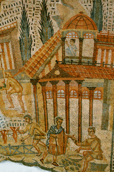
The bathing process began in the afternoon. It lasted two hours and varied individually. Baths were not only places for leisure, recreation, health, and physical training, but were centers for political and social life as well. The rich upper class had evening meals and social events there. The illustration shows a part of a mosaic floor of a Roman villa from the 2nd century AD . It was excavated near Bad Kreuznach (latin: Cruciniacum) and shows the sea god Oceanus as well as sea animals, ships and harbor scenes.
Wine Growing
In the Nahe valley and in the Hunsrück region, archaeological proof has been found that wine from the mediterranean area was already being imported in Celtic times. This was in connection with the trade in raw materials such as copper, pewter, and iron with the Etruscans of Vulci who lived in the Hallstatt era (800 to 475 BC, and so-called because of the important archaeological finds made at Hallstatt on the lake of Hallstatt in Austria). They developed and intensified the "European" trade in raw materials. Mediterranean eating habits were taken over after the conquest of the Romans, and wine trade became increasingly important. Because of legal limitations upon wine growing though, it did not develop as an independent branch of the economy until the 3rd century AD. The actual development of wine growing in the Mosel valley began with a decree by the Roman emperor Probus (278 to 280 AD), which allowed general cultivation of vineyards.
Germanic Wars
After Caesar's occupation of Gaul (51 BC), and the systematic exploitation and consolidation of the areas west of the Rhine, Drusus (12 to 9 BC) conquered the area right of the Rhine all the way to the Elbe. Due to continuous skirmishes with the Germananic tribes living there and the devastating defeat of the Romans at the battle of Varus, the Rhine became the border of the Roman empire (7 to 9 AD). Only under Emperor Vespasian (69 to 79 AD), was the land east of the Rhine again largely conquered. The provinces of Germania Superior and Germania Inferior were created in the years 83 to 85 AD, with their capitals of Mainz and Cologne.
There was constant danger of attacks by the Germanic tribes in the occupied areas. During the reign of Trajan (98 to 117 AD), the Romans built frontier fortifications with watch towers and battlements at regular intervals —the so-called Limes. The fortification project was completed in the year 150 AD. It was built in a line from Eining north of Neustadt on the Danube, Gunzenhausen, Dinkelsbühl, Böbingen east of Schwäbisch Gmünd, Jagsthausen, Miltenberg on the Main river, Gross-Krotzenburg near Hanau, Arnsburg south of Giessen, Butzbach, Großer Feldberg in Taunus, Arzbach near Bad Ems, Niederbiber near Neuwied, and Bad Hunningen near Linz on the Rhine.
The Marcomannic wars with their heavy casualties towards the end of the second century AD, were the first high points in the armed conflicts between the Romans and the Germanic tribes. Beginning in the 3rd century, the Germanic tribes began invading Roman territory increasingly often in their quest for land and plunder. Because the Romans were withdrawing troops for the defensive wars against the Persians, security in the area right of the Rhine deteriorated dramatically around the year 250 AD. The provincial reorganization by Diocletian around 297 AD did not take the Limes area into account anymore. Frankish and Alemannic peoples began a continuous push into empire territory. Only in the middle of the 4th century AD under Valentinian (364 to 375 AD), did the province's defense system again take solid form with the expansion of the Rhine line.
The constant movement of Germanic tribes into the area eventually brought Roman rule to an end in the 5th century. In the process, the Romans were not eradicated or chased out but were gradually assimilated into the Germanic people who outnumbered them greatly. As a rule, the towns and villages continued to be used although the economic system of the villa rustica ended abruptly.
Selected Key Dates
| 58-51 v. Chr. | Cäsar erobert Gallien mit dem Rhein als
Grenze |
| 17 v. Chr. | Trier wird gegründet |
| 13 v. Chr. | Mainz (Moguntiacum) wird Garnisonsstadt |
| 12-9 v. Chr. | Drusus unterwirft Germanen bis hin zur Elbe |
| 7-9 n. Chr. | römische Legionen werden in der Varus-Schlacht
aufgerieben, der Rhein wird wieder Staatsgrenze |
| 73-74 n. Chr. | erneute Eroberung rechtsrheinischer Gebiete unter
Vespasian |
| 83-85 n. Chr. | die Provinzen Germania Superior und Germania
Inferor mit den Hauptstädten Mainz und Köln entstehen |
| um 100-110 n. Chr. | Bau des Odenwald-Neckar Limes unter Traian |
| um 150 n. Chr. | die letzte Ausbaustufe des Limes ist beendet |
| 212 n. Chr. | Constitutio Antoniana: römisches Bürgerrecht für
alle Provinzbewohner |
| 213-486 n. Chr. | beständige Kriege gegen Franken und Alamannen |
| 259-273 n. Chr. | gallisches Sonderreich mit der Hauptstadt Köln, ab
271 Trier |
| 260 n. Chr. | Fall des Limes |
| um 275 n. Chr. | Franken überfallen das Nahegebiet und brennen die
römische Luxusvilla in Bad Kreuznach nieder |
| 392 n. Chr. | das Christentum wird Staatsreligion |
| 406 n. Chr. | Vandalen, Alanen und Sueben überschreiten den Rhein
und verwüsten Gallien |
| 451 n. Chr. | Schlacht auf den Katalaunischen Feldern gegen die
Hunnen |
| 455-459 n. Chr. | die Franken erobern Köln |
| 479 n. Chr. | Trier wird fränkisch |
| 486 n. Chr. | der Frankenkönig Childerich besiegt den letzten
Repräsentanten römischer Macht in Gallien |
Literatur
Ludwig Wamser, in Zusammenarbeit mit Christof Flügel und Bernward Ziegaus: Die Römer zwischen Alpen und Nordmeer. Zivilisatorisches Erbe einer europäischen Militärmacht. Mainz: von Zabern, 2000
|
Soonwald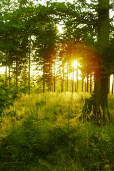
The Soonwald is one of the largest contiguous areas of forest in Germany. Its altitude (400-600 m; the highest peak is Ellerspring at 657 m), its low population density, and its distance from the large transportation routes of our time make it an ideal recreation area for people seeking peace and quiet. This wooded area is well developed. It has over 800 km of circular hiking paths with observation towers at the most beautiful spots, which afford spectacular panoramas. You can hike here for hours without ever meeting another human being, although traces of more than two thousand years of human history can be found everywhere. There are, on the heights of mountain ridges, ancient Celtic hilltop forts, surrounded by gigantic stone walls which easily exceed several hundred meters in length; there are ancient Roman long-distance roads, constructed some 2,000 years ago at a standardized width of 5 to 6 meters and protected by watchtowers at regular
intervals; and there are the remains of luxurious Roman villas. In addition, we find medieval fortresses and castles from the glory days of the political might of Sponheim and Kurtrier. And, there are churches and monasteries in the architectural style typical of Hunsrück with ingeniously painted surfaces and galleries; evidence of a very special race of people, who despite difficult living conditions and scant resources created their own works of art over hundreds of years. A race of people who, incidentally, you still encounter today on the farms of the elevated plains or in the village guest houses.
A picture book worth looking at: Uwe Anhäuser, Kultur-Erlebnis Hunsrück; Idar-Oberstein: Dr. Gebhardt & Hilden, 2000
Wanderführer: Wolfgang Bartels, Hunsrück; DuMont Buchverlag, 1996 und Norbert Forsch, Hunsrück; Deutscher Wanderverlag, 2000
Ergänzende Literatur: Landesgeschichtlicher Exkursionsführer Hunsrück; mit Beiträgen von A. Bauer, B. Lipps, W.H. München, E. Schaaf und K.H. Weichert, Herausgeber: Hunsrückverein e.V., Arbogast Verlag Otterbach, 1993 |
Idarwald mountain range with Idarkopf (746 m) 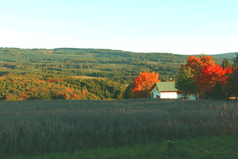
Lonely forests, peaceful creek valleys, and protected moors are the distinguishing features of Idarwald mountain range, a quartzite ridge whose two highest points are An den zwei Steinen (766 m) and Idarkopf (746 m). It is not only the extensive stretches of untouched nature that fascinates visitors and draws them from near and far. The "German Gem Road" from Idar-Oberstein leads through such picturesque places as Herrstein, Schauren, and Allenbach into the heart of the region. Relaxation, enjoyment of nature and the landscape, looking for minerals, and getting enthusiastic about the manufacture and processing of gemstones —all this can be combined here in the most pleasant way. What should also not be overlooked are distinct traces of a very old cultural landscape, whose roots reach far back into prehistoric times, which can be found everywhere. The reconstructed Celtic 'Altburg' fortress near Bundenbach or the 'Belginum' archaeological
park near Morbach allow you to experience this era up close. The only castle surrounded by water in Hunsrück is located near Morbach and reminds us of the Trier Archbishop and Elector Balduin von Luxemburg, one of the greatest protagonists of the Middle Ages in Hunsrück.
A picture book worth looking at: Uwe Anhäuser, Heimat am Idarwald; VG Rhaunen, 2001
Hiking guides: Wolfgang Bartels, Hunsrück; DuMont Buchverlag, 1996 und Norbert Forsch, Hunsrück; Deutscher Wanderverlag, 2000 |
Hochwald with the Erbeskopf (818 m) 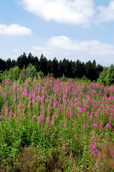
The Hochwald with its dense forests surrounding the 818 meter high Erbeskopf (the highest mountain west of the Rhine in Germany) is a fertile source of sagas and heroic tales. Many researchers of local history suspect that here in this pristine area of the Hunsrück plays one of the central scenes of the medieval Nibelungenlied.
In this place, according to the saga, Hagen von Tronje slew the noble hero Siegfried at the behest of Brunhilde. In fact, Drohnecken castle at the foot of Erbeskopf mountain is thought to be a possible family seat of Hagen von Tronje. Hagen's friend Hunold is thought to come from the nearby Hunolstein castle. Moreover, the towns of Worms and Alzey —the most important locations in the Nibelungenlied— are little more than a day ride on horseback from the Hunsrück mountain range.
A picture book worth looking at: Uwe Anhäuser, Heimat am Idarwald; VG Rhaunen, 2001
Hiking Guides: Wolfgang Bartels, Hunsrück; DuMont Buchverlag, 1996 und Norbert Forsch, Hunsrück; Deutscher Wanderverlag, 2000 |
The Mosel valley from Trier to Koblenz 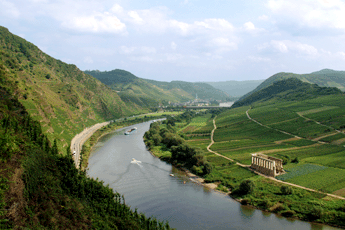
The Mosel river with its length of 545km, isn't even half as long as the Rhine. It has its source in the southern Vosges, from where it winds through the area of Trier in order to reach a branch of the Hunsrück.
From there, until it meets the Rhine at Koblenz, it flows through the deeply cut, winding valleys of the Rhenish slate mountains, creating a natural boundary at the north of the Hunsrück. The Mosel valley is an important wine growing area with famous names such as Bernkastel, Traben-Trarbach, Zell and Cochem.
Guide book: Reinhold Schommers, Mosel; DuMont Buchverlag, 2001 |
The Rhine valley from Bingen to Koblenz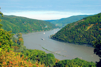
The Rhine has covered two thirds of its 1320 km long trip from the Swiss Alps (canton Graubünden) to the North Sea by the time it meets a branch of the Hunsrück near Bingen. Starting here, it flows through the slate mountains of the middle Rhine region. The traveler passes through a very narrow 300m deep ravine where the Hunsrück is a natural boundary. Then he traverses the fascinating landscape of Hunsrück on his way downstream.
Along this way he sees world famous places such as Bacharach, Kaub, or St. Goar with the overwhelming rock of Loreley. He sees Boppard with its impressive Rhine loop and picturesque Rhens. At Koblenz, at the mouth of the Mosel in the Rhine, he has reached the most northerly point of the branch of the Hunsrück. It isn't far from here and the Rhine widens, with all the narrows left behind. The low plains now determine the flow of the Rhine to the North Sea.
Hiking guide: Wolfgang Bartels, Hunsrück; DuMont Buchverlag, 1996 und Norbert Forsch, Hunsrück; Deutscher Wanderverlag, 2000 |
Three districts, one region: Nahetal-Hunsrück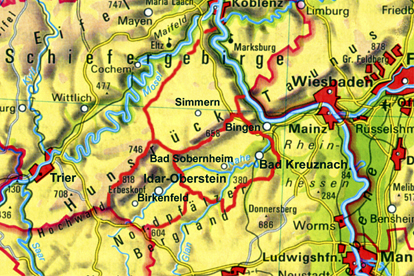
The region of the Nahe Valley-Hunsrück, the historic Nahegau, is divided into three administrative districts: to the east lies the district of Bad Kreuznach with its administrative seat in the city of Bad Kreuznach, to the north is the district of Rhein-Hunsrück with its administrative seat in Simmern, and to the west is the district of Birkenfeld with its administrative seat in the city of Birkenfeld. To the north there are also the districts of Cochem-Zell and Bernkastel-Wittlich bordering the Mosel river. Although the form these districts have today only dates from the administrative reform of the Rhineland-Pfalz region in 1969/1970, their origins can be found 200 years earlier. First under the French ruler Napoleon and then, after the reconstruction of Europe by the Viennese congress, under the Kingdom of Prussia. In fact, in the year 1798, under French
rule (1798-1814), the feudal system with its class privilege, serfdom and drudgery was eliminated, and, to ensure the division of authority, administrative and judicial powers were separated. All religious faiths received equal rights, and in 1804 these rights were implemented by a unified code of law, the Napoleonic civil code (Code civile Napoléon). As a result of an act of the Viennese Congress, the final act of 9 June 1815, the Prussians were awarded the area north of the Nahe. On 14 May 1816, the "royal government" in Koblenz officially announced the newly formed "districts" as administrative units, so this date is considered the official "birthday" of these districts.
It should be mentioned that the historical "Nahegau" only encompassed the eastern part of the District of Birkenfeld. The border ran along the Heimbach, a few kilometers west of Baumholder, along the Nahe up to Siesbach, just before Idar-Oberstein, along the Siesbach almost to the Erbeskopf, and from there over the ridge of the Idar forest to the Idarkopf. A look at the map here also shows that the mouth of the Nahe near Bingen (belonging to the district of Mainz-Bingen) and the northwestern part of Hunsrück (belonging to the districts of Cochem-Zell and Bernkastel-Wittlich) complete the region.
Along with the federal and state duties dictated, the district administration is also responsible for schools, social welfare, youth welfare offices, building development, land utilization, and fire protection. In addition, it deals with waste management as well as the maintenance of local streets. Above and beyond these central administrative tasks, the district also provides for the economic development of the community and region. In this respect, the expression "sustainability", as well as sustainable development, plays a central role, since its professed goal is to ensure the "continuance of a balance in the relationship between nature and its ability to regenerate, on the one hand, with its claims by humans, on the other". Alongside its obligatory duties, the district also takes on so-called "voluntary" duties, depending upon the tax income. Among these are the maintenance of adult evening classes, music
schools, museums, theaters, sports fields, and swimming pools.
|
|
|
 |
|
|
|
|
|
|
|
Hotel Maasberg Therme • 55566 Bad Sobernheim • Tel: + 49 (0 67 51) 87 60 • Fax: + 49 (0 67 51) 87 62 01 • E-mail: info@maasberg-therme.de |


