 |
|
|
| |
| Environment/objects of interest |
- Nahe Valley
- Soonwald
- Idarwald
- Hochwald
- Mosel Valley
- Rhein Valley
- Districts
The Celts in the Nahe Valley and the Hunsrück
People of European History
The Celts of the Latène age (475 to 20 BC) are named for the important archaeological finds at La Tène on the lake of Neuchâtel in Switzerland and are counted among the most important people of European history. Their central area of influence stretched from the Marne and Mosel, over southern France, and southern Germany, reaching to southern Poland and the Carpathians. The actual origins of the Celts is unknown. Myths and legends give a very contradictory picture.
Origins and Early History
Clear references to the history of the Celts are first found in the late Bronze age (the 13th century BC) with the beginning of the Canegrate culture. The name comes from the archaeological excavation at "Canegrate" near Legnano north of Milan, where important finds were made. The Canegrate culture was founded by Celts who came from the Northwest alpine region and settled in the area between the Lake of Maggiore and the Lake of Como. They brought a language with them from which "Old-Celtic" continuously developed. They lived in direct proximity to the Golasecca- Celts of the Ticino (their name stems from the important archaeological finds in "Golasecca" at the place where the Ticino river flows out of the Lake of Maggiore) and the Helvetians in the north whose settlements reached far towards southern Germany.
In the 13th century BC, the Mycenaeans ruled the mediterranean area. They were miners of metal deposits on a large scale. In the "world" of that time there was a large demand for the copper and tin ores necessary for the production of bronze. After the break down of the Mycenaean culture, other high cultures developed around the mediterranean area. These included the Assyrians, Phoenecians and Greeks. The power and wealth of the Phoenecians and Greeks was based upon extremely well organized sea trade which extended over the entire Mediterranean as well as along the Atlantic coast as far as Britain and Ireland.
Iron Ore Trade
With the emergence of the new raw material "iron", two more regions of Italy developed enormously both economically and culturally. This happened around 800 BC and included Vulci in the western area of Etruria and, in the east, Picenum on the Adriatic coast. It was the Etruscans of Vulci who intensified and developed "European" trade in raw materials during the Hallstatt era (800 to 475 BC) named for the area of archaeological finds at Hallstatt on the lake of Hallstatt in Austria. The most important trade routes were the "Tin Street" in the west which started in Marseille and continued along the Rhone and Saône rivers, past Bragny and further along the Seine and Loire rivers to Brittania and in the east, the "Amber Street" through the Moravian Gate into the Weichsel valley and on into the Baltic. These two trade routes were connected together by the Celts of southern Germany by the
"Danube Street".
An impressive monument to this epoch is the castle Heuneburg, located near the source of the Danube and built around the year 625 BC. For more than 150 years it was the most important Celtic trade center on the right of the Rhine. It was over these trade routes that Etruscan wine and the crockery for drinking it as well as an enormous amount of Etruscan art was brought to the Celtic people in exchange for raw materials.
The Hunsrück-Eifel-Culture
Around the year 475 BC, at the beginning of the Latène era, a fundamental change in the social structure of the Celts began. Its origins and reasons are unknown. A new and incomparable style of art developed, with unique ornamentation and design. It was found on weapons, equipment, and jewelry of the Celtic upper class. This "Celtic Style" as it is called by art historians, has its own masterpieces and iconography which is very obviously inspired by Celtic mythology. The region of Hunsrück-Eifel played a very crucial role here. The term "Hunsrück-Eifel-Culture" is used to describe the importance of this area for those times.
Unique works of art and gold smith's work found in the graves of the upper class attest to the economic prosperity of the Hunsrück-Eifel region at that time. The pictures show a drinking cup in the early Celtic style found in the
"Prince's grave" of Schwarzenbach/Hunsrück and dating from between 450 and 375 BC and gold rings of the tendril style found in the grave of the
"Princess" of Waldalgesheim/Nahe and dating from about 325 BC.
Hunsrück Economic Area
Iron ore, which could be surface mined (i.e., in Schwarzenbach), made up the basis of the wealth of the Etruscans. Raw iron was traded in the form of
"double point" bars of about 50 cm length. The smelting process used a large amount of charcoal, which caused a ruinous exploitation of the forests in the area (125 kg of iron ore and 125 kg of charcoal resulted in 10 kg of iron). The backbone of the trade was a well developed route which crossed over the Hunsrück heights and led to the Rhine and known up to today as the
"Via Ausonia". In addition, a north-south axis was created over the San Bernardino pass so that the Hunsrück region was directly accessible over the waterways of the Walensee, the lake of Zurich, the Limmat, the Aare and the Rhine up to the mouths of the Nahe and Mosel rivers.
The First High Civilization of West- and Middle Europe
It is assumed that writing came to the Celtic language area at the beginning of the Latène era. This created a basis for the development of an
"urban" economic and social system called an "Oppida-Civilization" (from the Latin oppidum which means urban). The largest "oppida" in the region were Otzenhausen in the Hunsrück and Donnerberg in the Pfalz, about 35 km south of the Nahe valley. The introduction of Celtic coin minting in the 3rd century BC was one more indication of a high civilization which prospered for more that 200 years. It should be remembered though, that the "Celts" never had an actual kingdom or state, but were organized into individual tribes and tribal connections ruled by a monarchy (only in the resistance to the Roman conquerers 58 to 51 BC, did the western tribes unite for a short time under Vercingétorix). In spite of this, the Celts attained a wide cultural federation in which there was probably one group of connected languages.
Celtic Expansion
Around 400 BC, the Celtic tribes began migrating to northern Italy, mostly to unpopulated land areas which they cultivated and built upon. They also conquered and plundered important cities like Como, Milan and Bologna. The city of Rome was under siege for seven months in 387 to 386 BC, until it was ransomed with gold. Only in 225 BC, after the victorious battle of Telamon, did Rome reconquor all of northern Italy and thereby becoming the super power of Italy. A new Celtic migration began then, this time in the northern direction.
Starting with their migration around the year 400 BC, the Celts became an important part of history. The first detailed reports are found in Ephorus (405 to 330 BC), Plato (429 to 347 BC), and Aristotle (384 to 322 BC). Later ones can be found in the historical works by Poseidonius of Apaneia (135 to 50 BC), Diodorus (around 50 BC) and the "Gallic Wars" of Julius Caesar (100 to 44 BC). These are usually rather biased pictures of the "barbarians" which were portrayed to be uncivilized wild men, violent, pugnacious, quarrelsome and belligerent. Such descriptions served Caesar well as reasons for bringing order to Gaul.
Oppida-Civilizations
The key to understanding the Celtic economic and social systems is their early urban way of living which was based upon a prosperous economy. The distinguishing feature of this Oppida-Civilization was its forms of settlement. The individual farmsteads (latin: aedificia), the unfortified villages (latin: vici) and the fortified towns (latin: oppida) were all a part of this. The individual farmsteads ranged from simple farms to the agricultural estates of the aristocracy. In the towns and villages people specialized in various kinds of craftmanship (i.e., ironworking or pottery making) and in certain well situated towns there were centralized political and religious activities. These political administrative units were called a "state" by Caesar (latin: civitas), meaning a political entity which comprised a certain territory and was governed from a central location and whose politics was in the hands of local elite groups. The Druids represented
religious leadership, administering the religious sites and were responsible for education and law. They were the embodiment of the church, high court and university.
The Fall of Celtic Culture
After Caesar's conquest of Gaul, during which more than a million people lost their lives, the Celts adapted astoundingly quickly to the Romanizing process that followed. This can be traced to the finds of artifacts in the graves of the Treverians in the Hunsrück. The newly founded Roman towns and villages added to this even though the crushing taxes imposed by the Romans led to many uprisings. With the end of the Roman Empire in the year 486 AD, and the start of migration, the last forms of the Celtic culture disappeared.
Celtic Fortresses
In the 4th and 3rd centuries BC, numerous fortresses and castles were built near settlements between the Nahe, Mosel and Saar rivers. The most well known of these are the Altburg near Bundenbach (expanded to its present form in about 120 BC) and Otzenhausen (the present form dating from around 80 BC). In the following list are the most important archaeological locations in the Hunsrück and Nahe valley for Celtic and early Celtic discoveries. All of these locations are in beautiful landscapes and are good destinations for exciting weekend excursions.
- Altenbamberg im Nahetal (nahe bei Bad Münster am Stein): Grabhügelfeld und Abschnittswall auf dem Schlossberg
- Bad Kreuznach im Nahetal: Ringwall auf der "Gans"
- Brauweiler im Nahetal (nahe bei Kirn): Grabhügelfeld
- Bundenbach im Hahnenbachtal (zwischen Kirn und Rhaunen): restaurierte Altburg mit Freilichtmuseum
- Hochstetten-Dhaun im Nahetal (nahe bei Kirn): Grabhügelfeld
- Kirnsulzbach im Nahetal (nahe bei Kirn): Abschnittswall auf dem Bremerberg
- Langenlonsheim im Nahetal (nahe bei Bad Kreuznach): Grabhügelfeld
- Neu-Bamberg im Nahetal (nahe bei Bad Münster am Stein): Fluchtburg auf dem Galgenberg
- Waldlaubersheim im Nahetal (nahe bei Bingen): Grabhügelfeld
- Alteburg im Hunsrück (nahe bei Gemünden): Fluchtburg
- Bescheid im Hunsrück (nahe bei Thalfang): Hügelgräberfeld
- Gehweiler im Hunsrück (nahe bei Hermeskeil): Grabhügelfeld in der Nähe der Grimburg
- Horath im Hunsrück (nahe bei Thalfang): Grabhügelfeld
- Ohligs-Berg im Hunsrück (nahe bei Bingen, Trechtingshausen): Abschnittswall
- Otzenhausen im Hunsrück (nahe bei Hermeskeil, Nonnweiler): Hunnenring auf dem Dollberg (Oppidum)
- Ringkopf im Hunsrück (nahe bei Allenbach, auch über Kirschweiler Festung): Wallanlage
- Wederath im Hunsrück (nahe bei Morbach): Grabhügelfeld und Museum direkt an der
"Via Ausonia"
- Perl-Borg im Moseltal (an der französischen Grenze): rekonstruierte römische Villa keltischen Ursprungs
- Pommern im Moseltal (nahe bei Cochem): Oppidum auf dem Martberg
- St. Goarshausen im Rheintal (nahe bei St. Goar): Befestigungsanlage Hünenberg
- Koblenz im Rheintal: Wallanlage auf dem Dommelberg
- Donnersberg in der Pfalz (nahe bei Rockenhausen): Ringwallanlage (Oppidum)
Literature
Sabine Rieckhoff und Jörg Biel: Die Kelten in Deutschland. Stuttgart: Theiss, 2001
|
Soonwald
The Soonwald is one of the largest contiguous areas of forest in Germany. Its altitude (400-600 m; the highest peak is Ellerspring at 657 m), its low population density, and its distance from the large transportation routes of our time make it an ideal recreation area for people seeking peace and quiet. This wooded area is well developed. It has over 800 km of circular hiking paths with observation towers at the most beautiful spots, which afford spectacular panoramas. You can hike here for hours without ever meeting another human being, although traces of more than two thousand years of human history can be found everywhere. There are, on the heights of mountain ridges, ancient Celtic hilltop forts, surrounded by gigantic stone walls which easily exceed several hundred meters in length; there are ancient Roman long-distance roads, constructed some 2,000 years ago at a standardized width of 5 to 6 meters and protected by watchtowers at regular
intervals; and there are the remains of luxurious Roman villas. In addition, we find medieval fortresses and castles from the glory days of the political might of Sponheim and Kurtrier. And, there are churches and monasteries in the architectural style typical of Hunsrück with ingeniously painted surfaces and galleries; evidence of a very special race of people, who despite difficult living conditions and scant resources created their own works of art over hundreds of years. A race of people who, incidentally, you still encounter today on the farms of the elevated plains or in the village guest houses.
A picture book worth looking at: Uwe Anhäuser, Kultur-Erlebnis Hunsrück; Idar-Oberstein: Dr. Gebhardt & Hilden, 2000
Wanderführer: Wolfgang Bartels, Hunsrück; DuMont Buchverlag, 1996 und Norbert Forsch, Hunsrück; Deutscher Wanderverlag, 2000
Ergänzende Literatur: Landesgeschichtlicher Exkursionsführer Hunsrück; mit Beiträgen von A. Bauer, B. Lipps, W.H. München, E. Schaaf und K.H. Weichert, Herausgeber: Hunsrückverein e.V., Arbogast Verlag Otterbach, 1993 |
Idarwald mit Idarkopf (746 m) 
Lonely forests, peaceful creek valleys, and protected moors are the distinguishing features of Idarwald mountain range, a quartzite ridge whose two highest points are An den zwei Steinen (766 m) and Idarkopf (746 m). It is not only the extensive stretches of untouched nature that fascinates visitors and draws them from near and far. The "German Gem Road" from Idar-Oberstein leads through such picturesque places as Herrstein, Schauren, and Allenbach into the heart of the region. Relaxation, enjoyment of nature and the landscape, looking for minerals, and getting enthusiastic about the manufacture and processing of gemstones —all this can be combined here in the most pleasant way. What should also not be overlooked are distinct traces of a very old cultural landscape, whose roots reach far back into prehistoric times, which can be found everywhere. The reconstructed Celtic 'Altburg' fortress near Bundenbach or the 'Belginum' archaeological
park near Morbach allow you to experience this era up close. The only castle surrounded by water in Hunsrück is located near Morbach and reminds us of the Trier Archbishop and Elector Balduin von Luxemburg, one of the greatest protagonists of the Middle Ages in Hunsrück.
A picture book worth looking at: Uwe Anhäuser, Heimat am Idarwald; VG Rhaunen, 2001
Hiking guides: Wolfgang Bartels, Hunsrück; DuMont Buchverlag, 1996 und Norbert Forsch, Hunsrück; Deutscher Wanderverlag, 2000 |
Hochwald with the Erbeskopf (818 m) 
The Hochwald with its dense forests surrounding the 818 meter high Erbeskopf (the highest mountain west of the Rhine in Germany) is a fertile source of sagas and heroic tales. Many researchers of local history suspect that here in this pristine area of the Hunsrück plays one of the central scenes of the medieval Nibelungenlied.
In this place, according to the saga, Hagen von Tronje slew the noble hero Siegfried at the behest of Brunhilde. In fact, Drohnecken castle at the foot of Erbeskopf mountain is thought to be a possible family seat of Hagen von Tronje. Hagen's friend Hunold is thought to come from the nearby Hunolstein castle. Moreover, the towns of Worms and Alzey —the most important locations in the Nibelungenlied— are little more than a day ride on horseback from the Hunsrück mountain range.
A picture book worth looking at: Uwe Anhäuser, Heimat am Idarwald; VG Rhaunen, 2001
Hiking Guides: Wolfgang Bartels, Hunsrück; DuMont Buchverlag, 1996 und Norbert Forsch, Hunsrück; Deutscher Wanderverlag, 2000 |
The Mosel valley from Trier to Koblenz 
The Mosel river with its length of 545km, isn't even half as long as the Rhine. It has its source in the southern Vosges, from where it winds through the area of Trier in order to reach a branch of the Hunsrück.
From there, until it meets the Rhine at Koblenz, it flows through the deeply cut, winding valleys of the Rhenish slate mountains, creating a natural boundary at the north of the Hunsrück. The Mosel valley is an important wine growing area with famous names such as Bernkastel, Traben-Trarbach, Zell and Cochem.
Guide book: Reinhold Schommers, Mosel; DuMont Buchverlag, 2001 |
The Rhine valley from Bingen to Koblenz
The Rhine has covered two thirds of its 1320 km long trip from the Swiss Alps (canton Graubünden) to the North Sea by the time it meets a branch of the Hunsrück near Bingen. Starting here, it flows through the slate mountains of the middle Rhine region. The traveler passes through a very narrow 300m deep ravine where the Hunsrück is a natural boundary. Then he traverses the fascinating landscape of Hunsrück on his way downstream.
Along this way he sees world famous places such as Bacharach, Kaub, or St. Goar with the overwhelming rock of Loreley. He sees Boppard with its impressive Rhine loop and picturesque Rhens. At Koblenz, at the mouth of the Mosel in the Rhine, he has reached the most northerly point of the branch of the Hunsrück. It isn't far from here and the Rhine widens, with all the narrows left behind. The low plains now determine the flow of the Rhine to the North Sea.
Hiking guide: Wolfgang Bartels, Hunsrück; DuMont Buchverlag, 1996 und Norbert Forsch, Hunsrück; Deutscher Wanderverlag, 2000 |
Three districts, one region: Nahetal-Hunsrück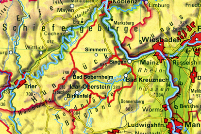
The region of the Nahe Valley-Hunsrück, the historic Nahegau, is divided into three administrative districts: to the east lies the district of Bad Kreuznach with its administrative seat in the city of Bad Kreuznach, to the north is the district of Rhein-Hunsrück with its administrative seat in Simmern, and to the west is the district of Birkenfeld with its administrative seat in the city of Birkenfeld. To the north there are also the districts of Cochem-Zell and Bernkastel-Wittlich bordering the Mosel river. Although the form these districts have today only dates from the administrative reform of the Rhineland-Pfalz region in 1969/1970, their origins can be found 200 years earlier. First under the French ruler Napoleon and then, after the reconstruction of Europe by the Viennese congress, under the Kingdom of Prussia. In fact, in the year 1798, under French
rule (1798-1814), the feudal system with its class privilege, serfdom and drudgery was eliminated, and, to ensure the division of authority, administrative and judicial powers were separated. All religious faiths received equal rights, and in 1804 these rights were implemented by a unified code of law, the Napoleonic civil code (Code civile Napoléon). As a result of an act of the Viennese Congress, the final act of 9 June 1815, the Prussians were awarded the area north of the Nahe. On 14 May 1816, the "royal government" in Koblenz officially announced the newly formed "districts" as administrative units, so this date is considered the official "birthday" of these districts.
It should be mentioned that the historical "Nahegau" only encompassed the eastern part of the District of Birkenfeld. The border ran along the Heimbach, a few kilometers west of Baumholder, along the Nahe up to Siesbach, just before Idar-Oberstein, along the Siesbach almost to the Erbeskopf, and from there over the ridge of the Idar forest to the Idarkopf. A look at the map here also shows that the mouth of the Nahe near Bingen (belonging to the district of Mainz-Bingen) and the northwestern part of Hunsrück (belonging to the districts of Cochem-Zell and Bernkastel-Wittlich) complete the region.
Along with the federal and state duties dictated, the district administration is also responsible for schools, social welfare, youth welfare offices, building development, land utilization, and fire protection. In addition, it deals with waste management as well as the maintenance of local streets. Above and beyond these central administrative tasks, the district also provides for the economic development of the community and region. In this respect, the expression "sustainability", as well as sustainable development, plays a central role, since its professed goal is to ensure the "continuance of a balance in the relationship between nature and its ability to regenerate, on the one hand, with its claims by humans, on the other". Alongside its obligatory duties, the district also takes on so-called "voluntary" duties, depending upon the tax income. Among these are the maintenance of adult evening classes, music
schools, museums, theaters, sports fields, and swimming pools.
|
|
|
 |
|
|
|
|
|
|
|
Hotel Maasberg Therme • 55566 Bad Sobernheim • Tel: + 49 (0 67 51) 87 60 • Fax: + 49 (0 67 51) 87 62 01 • E-mail: info@maasberg-therme.de |


